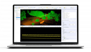
New Data Editing Toolsets & Model Fine-Tuning for Deep Learning-Based Vehicle Detection in v26.1 of Global Mapper
The release of Global Mapper v26.1 focuses on user experience & customization. Deep learning tools have been expanded in the Insight and Learning Engine™ (beta)
Global Mapper is an all-in-one GIS software solution driven by innovation, accessibility, and user feedback. The standard version provides users with tools for vector, raster, and terrain analysis. Global Mapper Pro® expands upon these tools to unlock terrain painting, photogrammetry, and lidar analysis including: automatic point cloud classification and feature extraction, along with Python scripting and more.
Version 26.1 of Global Mapper focuses on user experience and customization. To simplify the user interface the Digitizer toolbar buttons have been combined in a dedicated toolset. A similar toolset available in Global Mapper Pro, improves user interaction with the Manual Classification of Point Clouds. A new Scripting toolbar provides easy access to Global Mapper’s script creation and editing tools along with the Favorite Scripts option for quick execution of Global Mapper and Python scripts. Additional usability improvements include the explicit setting of camera position in the 3D Viewer and the ability to save text file import options for easy reuse.
The new features in Global Mapper Pro stretch innovation further. “This latest release includes exciting new updates to our AI-based tools,” states Product Manager, Jeff Hatzel. “We have expanded our machine learning-based point cloud classification methods to include powerlines. Additionally, we have updated the Insight and Learning Engine's deep learning image analysis tools with vehicle detection fine-tuning and custom model sharing.”
Continued access to the Insight and Learning Engine (beta) is available to all users of Global Mapper Pro version 26.1. A dedicated set of options in Configuration ensures users have access to the latest models from Blue Marble Geographics and allows the sharing of custom models created through fine-tuning and retraining. Continuing to expand the deep learning tools, the vehicle detection model can now be fine-tuned in Global Mapper 26.1, fully supported with tools for creating training data.
Improvements to point cloud data management in Version 26.1 include segmentation based classification for powerline identification and the extension of the Split Layers tool, which splits point clouds into layers based on attribute values such as: classification, point source ID, or return number. Advanced analysis of point clouds is improved with options in the Lidar QC tool to remove outlier control points after an initial comparison. Users will also notice improvements in Pixels to Points® drone/UAV-image analysis with color harmonization options.
For users looking to learn more about Global Mapper Pro’s photogrammetry processing tools, the Blue Marble Geographics Online Classroom has a new Pixels to Points course. These self-guided workflows cover the core features every user should know about, including ground control points, uploading drone imagery, generating point clouds and/or orthoimages, along with classifying ground points to create an elevation grid. Get your Pixels to Points certification: https://training.bluemarblegeo.com/
Explore the new features available now in Global Mapper v26.1. The user-friendly improvements and additions will enhance workflows across numerous industries. To download the latest version, or receive a trial of Global Mapper please visit www.bluemarblegeo.com/global-mapper-pro/.
###
As a leader in GIS and software development, Blue Marble Geographics® provides professional-grade tools to GIS users at every level. Founded in 1993, Blue Marble’s expertise spans the geospatial technology sector with a particular focus on coordinate conversion and management, lidar and photogrammetric point cloud processing, machine-learning, and user-driven product development.
Blue Marble's products include Global Mapper®, an all-in-one GIS application with a comprehensive array of data processing and analysis tools; Global Mapper Pro®, a suite of advanced tools for optimizing workflow efficiency, point cloud classification, along with generating orthoimages and 3D models from drone-captured images; and Global Mapper Mobile® an application for efficient data viewing and collection while in the field. Also offered is Geographic Calculator®, the industry standard for precise spatial data conversion and advanced coordinate system management now with tools available in the cloud. All these tools are also available as software developer toolkits and libraries.
For over three decades, Blue Marble Geographics' products have been used and trusted by organizations around the globe — including government agencies, universities, and Fortune 500 companies. For more information, visit: www.bluemarblegeo.com
Jessica Vachon
Blue Marble Geographics
+1 207-622-4622
email us here
Visit us on social media:
Facebook
LinkedIn
Instagram
YouTube
Other
Distribution channels: Agriculture, Farming & Forestry Industry, Aviation & Aerospace Industry, Building & Construction Industry, Real Estate & Property Management, Technology
Legal Disclaimer:
EIN Presswire provides this news content "as is" without warranty of any kind. We do not accept any responsibility or liability for the accuracy, content, images, videos, licenses, completeness, legality, or reliability of the information contained in this article. If you have any complaints or copyright issues related to this article, kindly contact the author above.
Submit your press release
